Saturday, January 2, 2010

Temples of Karnataka

Places visited: Hornad Annaporneshwari temple, Kalasa Kalaseshwara temple, Kudremuk National park-Kadambi falls, Hanumangundi falls, Lakya Dam, Karkala- Bahubali temple, Kollur Annaporneshwari temple, Murudeshwara - Shiva temple, beach, Udupi- Krishna temple, Malpe beach-St Mary's Island, Kukke Subramanya temple, Dharmastala, Charmadi ghat, Belur Channakeshava temple

Date-  26 Dec - 30 Dec 2009

Participants->My Family members

Mode of Transport- Fiat Palio Stile Multijet


Our Car

Total Kms- 1500 kms

Route we took->Bangalore->Tumkur->Arasikere->Kadur (My native halt)->Chikmagalur->Balehonnur->Hornad->Kalasa->Kudremuk->Karkala->Hebri->Haladi->Kollur->Bhatkal->Murudeshwara->Bhatkal->Kundapura->Udupi->St Marys Island->Kateel->Mudabidri-Kadri temple in Mangalore->Kasargod->Sulia->Kukke Subramanya->Gundya->Dharmastala->Ujire->Charmadi->Mudigere->Belur->Halebid->Kadur (Halt)


Can Plan in this way also

Bangalore->Tumkur->Tiptur->Arasikere->Kadur->Birur->Kallatigiri falls->Kemmanagundi->Baba Budanagiri->Mullianagiri->Balehonnur->Sringeri->Hornad->Kalasa->Kudremuk->Karkala->Hebri->Haladi->Kollur->Bhatkal->Murudeshwara->(If required can travel to Gokarna->Karwar->Sirsi etc) Or->Bhatkal->Kundapura->Udupi-> Kateel->Mudabidri-Dharmastala->Kukke subramanya->Sakleshpur (Shiradi ghat)->Hassan->Bangalore

OR you can visit 

Bangalore->Kunigal->Shravanabelogola->Belur->Halebid->Chikmagalur->Balehonnur->Sringeri->Hornad->Kalasa->Kudremuk->Karkala->Hebri->Haladi->Kollur->Bhatkal->Murudeshwara->(If required can travel to Gokarna->Karwar->Sirsi etc) Or->Bhatkal->Kundapura->Udupi-> Kateel->Mudabidri->Dharmastala->Kukke subramanya->Sakleshpur (Shiradi ghat)->Hassan->Bangalore

If you want to avoid Shiradi ghat due to bad road conditions, you can plan

Bangalore->Kunigal->Shravanabelogola->Belur->Halebid->Chikmagalur->Balehonnur->Sringeri->Hornad->Kalasa->Kudremuk->Karkala->Hebri->Haladi->Kollur->Bhatkal->Murudeshwara->(If required can travel to Gokarna->Karwar->Sirsi etc) Or->Bhatkal->Kundapura->Udupi-> Kateel->Mudabidri->Mangalore->Kasargod (in Kerela)->Visit Bekal fort, beaches, temples->Sulia->Jalsoor->Kukke subramanya->Dharmastala->Ujire->charmadi ghat->Mudigere->Chikmagalur->Mullianagiri->BabaBudanagiri->Kemmanagundi->Birur->Kadur->Arasikere->Tiptur->Tumkur->Bangalore

Important Distances-

Bangalore-Belur->220 kms

Belur->Halebid->15 kms

Belur->Chikmagalur->20 kms

Chikmagalur->Balehonnur->80 kms

Balehonnur ->Sringeri->40 kms (Right from Balehonnur is Sringeri)

Balehonnur->Hornad->40 kms (Left from Balehonnur is Hornad)

Hornad->Kalasa->5 kms

Sringeri->Hornad->80 kms (i.e. Sringeri->Balehonnur->Hornad)

Kalasa->Kudremuk->23 kms

Kudremuk->Karkala->50 kms

Karkala->Kollur->110 kms (Karkala-Hebri- 30 kms, Hebri-Kollur->80 kms)

Kollur->Byndoor->Bhatkala->Murudeshwara->Total (27+30+15=72 kms)

Murudeshwara->Bhatkal->Kundapur->Udupi->total (15+35+25)=75 kms

Udupi->St Marys Island-> 10 kms

Udupi->Kateel->40 kms

Kateel->Mudabidri->30 kms

Mudabidri->Mangalore->35 kms

Mudabidri->Dharmastala->50 kms

Mangalore->Kasargod->40 kms

Kasargod->Bekal fort->15 kms

Kasaregod->Jalsoor->Sulia -> Total (40+8)->48 kms

Sulia->Kukke subramanya->4o kms

Sulia-Madikeri->60 kms

Kukke subramanya->Gundya->Dharmastala->60 kms

Dharmastala->Ujire->Charmadi->Mudigere->Belur->Total (10+25+30+30)->95 kms


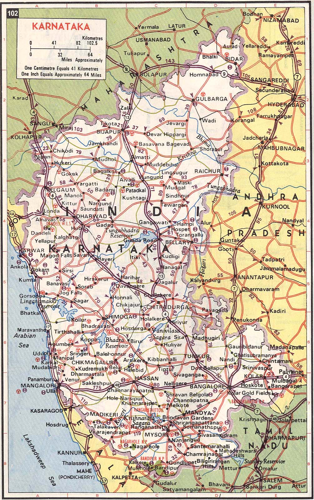
Few Maps for Reference:

http://aquarium.lipetsk.ru/discovery/India2004/karnataka-map.jpg

http://globalmotorcycletours.files.wordpress.com/2007/04/karnataka-map.jpg

http://www.nivalink.com/karnataka/pics/map.jpg


Our Trip:

We started on 25th Dec from Bangalore to Kadur and halted in our Native.

Our first day plan was Kadur->Chikmagalur->Balehonnur->Hornad->Kalasa->Kudremuk->Karkala (Halt)

 Next morning, we started our journey by 6:30 am. Kadur to chikmagalur took 1.5 hours and another 1.5 hours from Chikmagalur to Balehonnur. From Balehonnur, Sringeri is 40 kms. As all of us had visited Sringeri few months back, we decided to skip it. We even skipped Balehonnur Rhambapuri Mutt. From Balehonnur we drove through the beautiful roads to Hornad. The Roads here are single lane roads through the ghat section, so drive carefully. after visiting Hornad Annapoorneswari temple, we drove to Kalasa. Enroute we had planned to visit Ambatirta Falls(a Shooting spot where lot of Kannada films are shot). The 3 km stretch leading to Ambatirta was in very bad condition and hence we skipped it. If you have time, then Ambatirta is a place worth visiting. 

Drive to Kalasa

Kalaseswara Temple- Kalasa

Kudremuk- Tea Estate

Hanumangundi Falls


Hanumangundi Falls


Kadambi Falls

After visiting Kalaseswara temple, we drove to Karkala via kudremuk. Inside Kudremuk National park, we visited Lakya dam, Kadambi falls and Hanumangundi falls. To reach the base of Hanumangundi falls, you have to scale down around 300 steps. Hanumangundi falls is well maintained and you need to pay an entrance fee of 20 Rs per head. The roads from Kalasa to Karkala is good. In Karkala we visited Bahabuli temple and Venkateshwara temple. Both the temples are 1 km from Karkala busstop. We halted in Hotel Swagath in Karkala Bus stop by 8 PM.

Day 2:

Started from Karkala around 9 Am and drove to Kollur via Hebri, Haladi. Roads are having potholes in few stretches and is a single lane road. So at times you are required to go off the road, if vehicles come from opposite side. The drive is very scenic. After visiting Mookambika temple in Kollur, we drove to Murudeshwara via Byndoor->Bhatkal. After visiting temple and beach in Murudeshwara, we drove back to Bhatkal by 7 PM and halted there. There are lots of hotels and Lodges in Murudeshwara, but it is difficult to get accomodation in peak seasons.


Murudeshwara Shiva Temple

Murudeshwara

Murudeshwara

Murudeshwara


Day 3:

We started early by 6 am and drove to Udupi via Byndoor->Kundapura. After visiting Krishna temple in Udupi, we drove to Malpe beach and Visited St Marys Island, which is 10 kms from Udupi. You need to take a boat ride of 30 minutes to reach St Marys Island from Malpe Harbour. Per head charge for Boat ride is 80 Rs (To and Fro ride Fare). After reaching St Marys Island, you can play in the water, walk around the Island and return back. There is no food/ accomodation present in St Mary's Island. you get only water, cool drinks and some snacks in Island. There is no time restriction to stay in the Island. there are lots of return boats, so spend more time in the Island and you can return by 5 pm also.

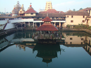
Udupi- Shri Krishna Temple

St Mary's Island


My Brother-Enroute St Marys Island

St Marys Island

After enjoying St Mary's Island, we drove to Kateel and visited DurgaParameshwari temple. From Kateel, we drove to Mudabidri and visited Thousand pillar temple. From Mudabidri, we drove to Mangalore and this dirve took us more than 1 hour, as the road condition was bad . We visited Kadri temple in Mangalore and Drove to Kasargod. Our plan was to halt in Kasargod , visit Bekal fort, beach, temples near by and travel to Kukke subramanya. Unfortunately we were informed that there was a BJP called Kerela Bundh on next day and this ruined our plans.

We drove from Kasargod to Sulia via Jalsoor and halted in Sulia, as it was around 11:30 PM.


Kateel- DurgaParameshwari Temple

Mudabidri- Thousand pillar temple


Day 4:

We started from Sulia and drove to Kukke subramanya by 9 AM. Roads are good , but is very narrow and you are required to go off the road to give way to vehicles coming in opposite direction. The entire drive is through ghat section and it took us arounf 1 hour to reach Kukke subramanya. After visiting Kukke subramanya temple, AAdi Subramnaya temple, Aadi Ganapati temple, Shri Vana DurgaDevi temple, Kumaradhara River we drove to Dharmastala via Gundya. Drive from Subramanya to Dharmastala is scenic and took us around 1.5 hours. In Dharmastala we visited Manjunatha swamy temple, Bahubali temple and drove towards Ujire. You can even visit Manjusha Car museum, Historical museum in Dharmastala. On way to Ujire, we visited Shri Rama Mandir. From Ujire we drove to Belur via Charmadi->Mudigere. Road from Charmadi to Mudigere is through Ghat section and there are lot of potholes in this stretch for around 30 kms. But this road is very good compared to Shiradi ghat. The drive throught the Ghat section is very scenic. From Mudigere to Belur also, the road is in bad. So it took us around 3 hours to reach Belur from Dharmastala. We visited Belur Channakeshave temple. the temple is very good and you can easily spend 2-3 hours by looking at the sculptures. It is recommended to take a guide to get more information and know the place better. After visiting Belur temple, we drove to Halebid. Halebid temple closes by 6 PM. So we had to skip it as we were late. Belur temple closes 8 PM. 

Kukke Shree Subramanya Temple

AAdi Ganapati Temple, Subramanaya

Places of intrest in Dharmastala

Bahubali temple, Dharmastala

Shri Rama Mandir near Dharmastala

View of Charmadi Ghat

Belur-Channakeshava Temple


From Halebid, we drove to kadur via Banawara and halted in our native

Few Points to Remember:

1. Plan your journey considering the road conditions. Drive to kollur from Karkala took us 3 hours. Drive to Belur from Dharmastala took us 3 hours

2. Plan considering time taken to get Darshan in temples. It took us 1 hr in Hornad, 1.5 hrs in Kukke subramanya, 1 hr in Udupi to get Darshan. If you are visiting temples, in peak season, then have a cushion of 1-2 hours for all these important temples

3. Drive carefully, as the roads are narrow at places and you will be required to go off the road at places to give way to vehicles coming from opposite side. To go off the road you need to be careful, as road and off road are not even and off road at places is almost 20 - 30 cms below road level.

4. If you are visiting other state, then better read papers or get info from friends / relatives about any Strikes/ bundh. Else you may waste your time and get into troubles.

5. At most of the places, you get Decent Double rooms in hotel for 300-400 Rs.


Monday, October 6, 2008

Devarayanadurga and Namada Chilume Biking

Date: 16 August 2008
Participants: Harish,Jatin,Vivek,Nagesh,Vinay,Vivek
Mode of Transport : Bikes

Total Distance covered :
150 Kms

Route:
Majestic->Yeshwantpur->Nelamangala->Tumkur Road->Tumkur Toll gate->Dabbaspet->Shettar palya->Devarayanadurga.
Distance : 60 Kms from Bangalore Bus stop

Transport facilities:
There are direct KSRTC buses from Bangalore to Devarayanadurga. Else you can reach Dabbaspet and catch private buses from Dabbaspet.Once you reach Devarayanadurga, you can hire a auto to visit places around.

How to Reach Devarayanadurga:

1. In Tumkur Toll road, you get a first Flyover, which is at Dabbaspet. Do not take the Flyover. Instead take the Left Road next to Flyover. Travel for 200 meters and take a right turn below the Flyover and from here Devarayanadurga is 20 Kms.In case you get confused ask localities for directions at Dabbaspet.
At Dabbaspet Flyover, if you take Left road and then go towards left you will reach ShivaGange. 20 Kms towards Right is Devarayanadurga
Even there are many Signboards from Dabbasapet which will guide you to Devarayanadurga.
On this route you get Devarayanadurga first, and then as you go towards Kyatsandra, you get Hanuman (Suryanjaneya temple) and Shankara temple, a little further is Namada Chilume and then Siddaganga mutt (different from Siddagange betta) and a kilometer from there is Kyatsandra where you hit Banglore Tumkur road.
2. The other route from Banglore is from Kyatsandra. About 1Km after crossing second toll gate on Tumkur road take right at Kyatsandra. After crossing railway level cross you reach Siddaganga Mutt then Namada Chilume then Hanuman Temple and finally Devarayanadurga.

Roads on both the routes are in good condition.


Places of Intrest around Devarayanadurga:

Siddarabetta 16 kms
Siddaganga : 12 Km
Goravanahalli :
Namada Chilume :
Suryanaganeya temple :
Vidya Shankar swamy temple : 5 Km
Veeranjiya temple : 6 km
Siddganga mutt : 9 km
Goravanahalli Sri Lakshmi temple : 21 km
Shivaganga Sri Gangadeeshwara swamy temple : 33 km


Route map

Background for this trip:
August 15th long weekend was nearing and plans for a long trip / trek got washed away, due to heavy rains in most of the places. Jatin suggested one day biking to Devarayanadurga and surrounding places. 6 of us were intrested and started the biking trip on 3 bikes. We thought it will be just another place like Nandi hills or even bad. But this place really turned out to be an amazing, thanks to the rains which made the places more greener and the climate was also amazing.


Biking (Me , Vinay & Preeetham)


Group Photo (L -R Vinay,Jatin,Harish,Preetham,Nagesh,Vivek)

Enroute to Devarayanadurga, we stopped for some photography session. We came across a beautiful lake on the way where we did some stunts, enjoyed the cool weather and moved further.


Lake on way to Devarayanadurga


Some Stunts


Some stunts

Devarayanadurga:
Devarayanadurga is a Hill station located at a altitude of 3896 feet above sea level.
Yoga and Boga Narasimha temples are located here. There is a Rathotsava every year on Full moon day (Hunnime in Kannada) of march.


YogaNarasimha temple

Yoga Narasimha temple is located on top of the hill, where as Boga Narasimha temple is located at base. By vehicle you can almoist reach to top of the hill. There is enough space to park the vehicles at top. After that you need to climb 75-100 steps to reachYoga narasimha temple. There are few stalls on top of hill where you can get fruits, bhel puri, and other eatables. Even water is available on hill top. There is a small kalyani also in the temple premises. From temple you can travel further to hill top from where you can see the entire Devarayanadurga surroundings. The view is similar to view you get from Nandi hills top. You can even see the remains of fort that is built around.


Stalls at entrance of Yoga Narasimha temple


Entrance of Yoga Narasimha temple


Road leading to Yoga Narasimha temple

There are facilities to halt in Deverayanadurga which is provided by Temle authorities. Even Prasada (Free lunch) is provided at Boga narasimha temple premises.
We had our lunch in the temple premises and after that we started to Namada chelume. The drive to Devarayanadurga and Namada chilume is very good, with entire stretch covered by lush greenery.


View from Devarayanadurga peak


Snap taken @ Devarayanadurga peak

Namada Chilume
From Devarayanadurga, Namada Chilume is located at a distance of around 5 Kms. In Namada chilume there is a Deer Sanctuary and is a lovely scenic place surrounded by hills and Greenery.It started raining by 5pm and the place looked even more beautiful. The hills surrounding were covered by mist and was similar to view we get in madikeri / Kudremuk or any other trek


Namada Chilume (Water flows for 24X7X365)


Deer park at Namada Chilume

There is a saying that Lord Rama wanted to apply Naama (On Fore head) and he could not find water. so he shot a arrow and water emerged from the rock. From then till date water comes from this rock and till now it has not dried up, is the saying.Hence this place was coined Naamada Chilume.


Beautiful sceenery @ Namada Chilume

Another sceenery @ Namada Chilume

In Namada chilume there was some fun time, when Vivek, Preetham and Vinay were involved in some duet songs related to rain.

Even you can Find Surya Anjaneya temple which is located between Devarayanadurga and Naamada Chilume . By 6 Pm we left Namadachilume, took Kyatsandra route and reached Tumkur highway. Had Dosa and some snacks in Tumkur hotel and returned home getting fully drenched in the heavy rains

Points to Note:

1. The place can be reached within 1-2 hours from Bangalore.
2. Roads are in good condition. Even you get food / water at all places.
3. You can take your parents / elders as they will be happy visiting the temples. We can enjoy thew greenery and the nature around and even do some trek
4. If you start early, you can even cover Goravanalli temple and other places around Devarayanadurga
5. There are direct buses to Goravanalli and Devarayanadurga from Bangalore. It is prefered if you have your own vehicle, which will help you to cover more places

Sunday, October 5, 2008

Kudremuk Trek : Gangadikal and Kurinjal peak

Date: 1st and 2nd October 2008

Places : Kudremuk- Trek to Gangadikal and Kurinjal. Visited Hanumangundi water falls and Lakya dam

Participants: Harish M,Jatin,Rohit,Vivek, Ravi,Mamatha,Soumya,Rashmi,Praveen,Sameer,Venkat,Vinay,Nagesh,Harish G,Gururaj

Mode of Transport: Tempo Traveller (Driver :Kantaraj)

Route: Bangalore->Kunigal->Hassan->Belur->Mudigere->Kottigehaara->Kalasa->Kudremuk – Distance approximately 350 kms


Accomodation : Bhagavathi Nature camp


Book Bhagavathi Nature camp in advance by calling:

RFO Kudremuk, Phone: 08263-255998

OR

DCF Karkala Phone : 08258-231183


Permission to Trek : RFO Kudremuk, Phone: 08263-255998


Trek and Accomodation charges:

Entry Fee : Rs 40 per head

Trek Fee per day : Rs75 per day

Guide Fee : Rs 150 per day

Dormitary Fee at Bhagavathi : Rs 75 per day / per person


SunRise on way to Kudremuk


Trekking routes at Kudremuk

Background of Trek:

Rohit, Vivek and Co had planned for this trek cum trip almost 3 weeks in advance. I had opted out as I was busy with some arrangements for my Elder brothers marriage. Their plan was trek for 2 days and trip for next 2 days. I was OK with 2 day plan, so I had opted out. Suddenly on Saturday (27 th Sep),Jatin called me asking me whether I can book a TT for them, as they could not get Bus tickets and he also informed that I can join them for first 2 days, as only 9 of them are going and 3 more were supposed to join them on 2nd day. So I was OK with the plan. I went ahead and booked the TT from Naveen (our usual TT owner Mob : 9740866433) and requested him to send Kantraj as driver. TT was in good condition having Pushback seats and Video coach.

As per the plan we picked up all and left Bangalore around 11:30 PM on Oct 1st. Stopped in between in Cafeday, had some coffee, snacks and reached Kudremuk by 7 AM.


Details of Places:


About Bhagavathi Nature Camp:

It is located at a distance of 9 Kms from Kudremuk towards Karkala side. It is located in centre of Forest surrounded by lush greenery and mountains. Even a stream flows behind the Dormitary. You can even opt for Tents, which will cost you Rs 100 per head. Book bhagavathi Nature camp in advance by Calling the above mentioned numbers.

Reg Food : There is cook at Bhagavathi, who will take care of your food. It is recommended that you carry all necessary food materials required to prepare food. You need not carry utensils, plates, firewood , gas etc. Smoking, Alcohol, Firecamp are prohibited in Bhagavathi. Bhagavathi is located in centre location by which you can easily access bhagavathi temple – 1 km, Hanumangundi water falls - 8 kms, Gangamoola 6.0 kms, Kurinjal trek 0 kms, Gangidal trek , Lakya dam 4.5 kms and Kudremuk town -10 kms.


Bhagavathi Nature camp entrance


Group photo @ Entrance of Bhagavathi Nature Camp


Bhagavathi Nature Camp


Tents @ Bhagavathi Nature Camp


Roads leading to Dormitary inside Nature camp


Dormitary


Enjoying morning walk @ Bhagavathi nature camp

About Gangadikal Trek : The Trek route starts approximately 4-5 kms from Bhagavathi nature camp . It is recommended that you have your own mode of transport to easily access all these places. The trek is 4km a side and is fully through grassland and finally you scale the Gangadikal peak. Atop the peak you get beautiful view of Kurdemuk range of peaks and in between you can spot the backwaters of Lakya dam, an mind blowing screenery. Even we were able to spot a group of bisons and a snake. The Trek route is a proper trekking route. Trek can be easily completed in 3-4 hours. We covered it on oct 1st by 3 PM.


Starting point of Gangadikal peak


Trek route to Gangadikal peak


Trek Route to Gangadikal peak


View from top of Gangadikal peak


View from top of Gangadikal peak


On Top of Gangadikal peak

Hanumangundi Falls: After finishing Gangadikal trek, we visited Hanumangundi falls. This is a beautiful falls which is well maintained. You need to scale down 150-200 steps to reach the base of falls. Entry fee is Rs 20 per person and entry is allowed till 4:30 pm. The water falls from a descent height of approximately 50 feet and is a real beauty to watch. You can swim at the base of falls and even take bath. Myself , Vivek and Vinay got into the water and took a refresing bath and did some swimming. Others just watched the beauty of the falls and were fully involved in Photography sessions


Hanumangundi water falls

Lakya Dam : After visiting Hanuman gundi falls,we visited Lakya Dam. Entry is Free of cost, but Photography is strictly prohibited. This is damn constructed by KIOCL (Kudremukh Iron Ore Company Limited) to fill it with the tailing left behind after recovery of the iron ore. There is no water here that can be used.You can see a layer of fine sand layer across the entire dam surrounded by lush green mountain ranges. We took icecream and walked across the dam enjoying the beauty of the surroundings.


Lakya Dam view (Snap copied from Net)


Halt At Bhagavathi : After visiting Lakya dam, we went to Kudremuk town to buy food material required to prepare for our dinner and next morning breakfast. As 4 of us were returning back on 2’nd night, we even booked our return tickets at Kudremuk. We got 4 Sleeper coach tickets for suguma tourist bus costing Rs 350 per head.Most of us called up our homes here, as all our cells were out of coverage. Only BSNL coverage is there in Kudremuk.We reached Bhagavathi nature camp, had our dinner (Rice / Sambar) and went to sleep by 1 pm, as few of us were very much involved in playing Poker.


Next day morning, I went to Kudremuk town in TT in order to pickup Nagesh, Gururaj and Harish G who were supposed to land from Bangalore . After picking up them and getting permission for them also to trek, we returned to Bhagavathi, had our breakfast ( Lemon rice, Maggi) and Tea. We were also accompanied by a new person, named Mallikarjun , who was waiting in Kudremuk RFO eager to join for trek with some group.


Kurinjal Trek : Our initial plan was to trek to Kudremuk peak. But as 3 of them were joining us only by 7 am or late and 4 of us were supposed to leave the same night by 8 pm back to Bangalore, we opted for Kurinjal trek. Kudremuk trek is a lengthy trek , almost 18 km per side, out of which 6 kms can be covered by jeep. Kurinjal trek starts from Bhagavathi nature camp. We crossed 2 small streams and came across a tunnel which was constructed for carrying out mining activities. Now the tunnel is closed. After that we contined our trek which is entirely through jeep track , which was quite boring. We were welcomed by many leeches and uprotten trees on the way. The trek route is through the forests for 50 % and grassland for next 25 %. The entire trek route is however covered by beautiful peaks all around you. You find a haunted house few meters below the peak. We had our lunch (MTR , snacks etc) here. From here only 7 of us went to peak which is through huge grassland and rocks. Others went back from this place. Scenic view from the peak is really mind blowing. You can see the entire peak ranges on all 4 sides from the peak. After scaling the peak we returned back, spending some time in the stream.


Crossing stream on way to Kurinjal Trek


Tunnel on way to Kurinjal peak

Uprooten trees enroute Kurinjal trek

Scaling Kurinjal peak


Relaxing @ Stream while returning from Kurinjal peak


On way to Kurinjal peak


On Way to Kurinal peak


On Top of Kurinjal peak


End of trek : After finishing Kurinjal trek, we gathered at Bhagavathi. Myself, Vinay, Praveen and Venkat said bye to others and went to Kudremuk town to catch our bus back to Bangalore. Others continued their journey in TT to halt at Karkala and then visit Udupi temple, St mary’s Island and Kapu beach on 3rd Oct and Koodlu teeretha falls, Agumbe sunset and Sringeri temple on 4th October. I will be missing Koodlu teertha falls, as it is a beautiful falls and I have not visited it till now. Other places I had already visited, so wont miss them much.

Plan will be to either trek Kudremuk peak or Narasimha parvatha or Sita Bhumi or Valikunja peak and Visit Koodlu teertha in December 2008 .Hope that it works out.


Points to Note:

  1. You can call up Kudremuk RFO and check in advance wheter trekking is allowed or not. Usual in rainy season and during heavy rains, trekking is prohibited
  2. You can call up Karkala DCF or Kudremuk RFO and book you accommodation in Bhagvathi Nature camp. It is a beautiful place to stay and has easy access to all places. Even the Guide will be available from the Nature camp.
  3. Carry material required to prepare food from Kudremuk town, as Bhagvathi is located 10 kms from Kudremuk town and usually the cook will not have much material to prepare food.
  4. Recommended to have your own modes of transport, as frequency of buses to Bhagvathi and other places is very less from Kudremuk
  5. You need not worry about researching Trek routes, as guide will be sent from RFO office. You can choose any trek.
  6. Carry umbrella, extra cloting, snuff / dettol etc for leeches
  7. If you want to reach Kudremuk using public transport, there is only 1 direct KSRTC Sarige bus from Bangalore to Kudremuk. There are plenty of KSRTC bus / tourist buses which go to Kalasa. You can get down at Kalasa and from Kalasa , Kudremuk is 20 kms. There are plenty of private buses which ply from Kalasa to Kudremuk. From Kudremuk, if you want to return to Bangalore, you can book Sugama travels, who take care of your journey till Kalasa through local private bus and from Kalasa, Sugama tourist buses are available